
News Summary
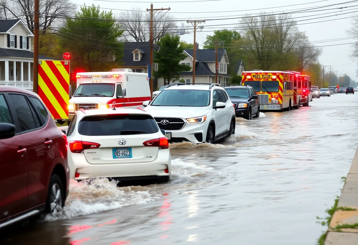
Grand Rapids faced significant flash flooding on September 23, stranding vehicles and creating hazardous road conditions. Heavy rain, reaching up to 3 inches in certain areas, primarily impacted locations south of Cascade Road. The National Weather Service noted that recent thunderstorms resulted in total rainfall of up to 4 inches across West Michigan, surpassing typical rainfall for the preceding months. As the Grand River levels rise to dangerous stages, officials urge residents to avoid flooded roads and prioritize safety amid ongoing weather alerts.
Grand Rapids, MI experienced significant flash flooding and vehicle stranding due to heavy rain on September 23, leading to hazardous conditions on roadways throughout the city. Reports indicate that isolated rainstorms resulted in up to 3 inches of rain in various locations, leaving many drivers struggling to navigate flooded streets.
Residents and visitors alike faced dangerous conditions as heavy rains fell for approximately 30 minutes, leading to flooded roads and stalled vehicles primarily in areas such as East Paris south of Cascade Road, Spaulding Avenue SE south of Cascade Road, and Burton Street SE west of Calvin Avenue. Many drivers were seen turning around to avoid the rising floodwaters, as highlighted in videos circulated on social media showing vehicles at 28th Street SE and East Beltline Avenue attempting to navigate through the flooding.
The National Weather Service reported that episodic thunderstorms over the past three days contributed to rainfall totals ranging from 1.5 to 4 inches across West Michigan, greatly exceeding the region’s typical rainfall for the preceding months. The Holland area specifically received between 3 to 4 inches of rain over this period, marking a striking contrast to the totals of just 4 to 5 inches experienced during the entire three-month span of June, July, and August.
The current state of the Grand River, measured at 12.72 feet, indicates it is in the “action” stage of flooding. This level is significantly above the typical 3 to 5 feet range and suggests potential complications for the surrounding areas. The river’s flooding classification rises from “action” to “major flooding,” with critical thresholds established at various feet levels. At 12 feet, monitoring for potential flooding increases, while at 18 feet, minor flooding may begin impacting parks and roadways. Should the water level reach 21 feet, significant protective measures would be enacted as flooding affects developed areas, and at 23 feet or higher, major flooding could result in extensive inundation of residential and commercial regions, leading to serious property damage and necessitating widespread evacuations.
As a precautionary measure, officials are urging residents to remain weather aware and to avoid driving through flooded roadways. The established safety mantra urges drivers to remember: “turn around, don’t drown.” It is essential for residents to prioritize safety and heed local advisories during such severe weather events.
This event has drawn attention to the impact of extreme weather on urban areas, highlighting the need for preparedness as climate patterns evolve. Local anecdotal accounts suggest that while certain areas of Grand Rapids are prone to flooding, the intensity experienced on this occasion was unusually severe, prompting discussions about infrastructure and flood management in the area.
As the community assesses the aftermath of the storms, emergency services remain vigilant, providing support where needed and monitoring waterways for any further developments in the flooding situation. Continued efforts to educate residents on safety practices during severe weather are crucial in minimizing risks associated with flash flooding in the future.
Deeper Dive: News & Info About This Topic
HERE Resources
Governor Declares State of Emergency in Houghton Due to Flooding
Michigan Under Air Quality Alert Due to Canadian Wildfires
Michigan Braces for Severe Storms with Tornado Risk
Additional Resources
- MLive: Isolated downpours flood roads in Grand Rapids area
- Wikipedia: Flood
- WZZM: Flooded Grand River Stages & Water Levels
- Google Search: Grand Rapids flooding
- Fox 17: Grand River at Action Stage in Downtown Grand Rapids
- Encyclopedia Britannica: Flood
- Wood TV: Grand Rapids Riverfront Projects to Reduce Flooding Risk
- Google News: Grand Rapids flood management

Author: STAFF HERE GRANDRAPIDS WRITER
The GRAND RAPIDS STAFF WRITER represents the experienced team at HEREGrandRapids.com, your go-to source for actionable local news and information in Grand Rapids, Kent County, and beyond. Specializing in "news you can use," we cover essential topics like product reviews for personal and business needs, local business directories, politics, real estate trends, neighborhood insights, and state news affecting the area—with deep expertise drawn from years of dedicated reporting and strong community input, including local press releases and business updates. We deliver top reporting on high-value events such as ArtPrize, Festival of the Arts, and World of Winter. Our coverage extends to key organizations like the Grand Rapids Chamber of Commerce and Grand Rapids Community Foundation, plus leading businesses in furniture, healthcare, and technology that power the local economy such as Steelcase, Spectrum Health, and Meijer. As part of the broader HERE network, including HEREDetroitMI.com, HERENorthville.com, HERENovi.com, and HEREPlymouth.com, we provide comprehensive, credible insights into Michigan's dynamic landscape.